 Just outside Agaete, the green landscape gives way to rugged and wild hills sparsely covered with rickety vegetation, which sink almost vertically into the sea. The western part of Gran Canaria is by far the least visited by tourists.
Z Agaete do San Nicolas Village
Some 40 km separates Agaete from the southern village of Aldea de San Nicolas, and the 40 km is one of the most winding routes on the island (apparently it is on it 365 turns), but also the most spectacular – to run her over, you need to have strong nerves and a lot of skill. The picturesque GC-200 leads through the small town of El Risco, from which an unpaved road leads to the charming and almost always uninhabited Playa dcl Risco. A few kilometers away in the rock the attractive Mirador del Risco, from which there is a wonderful view of the entire north-west coast of Gran Canaria and the vastness of the ocean. In good weather, you can see Tenerife and its highest point on the horizon, Teide peak
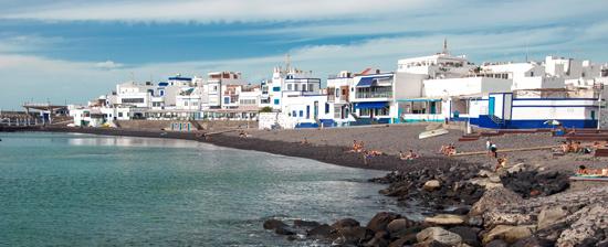
Village of San Nicolas
Aldea de San Nicolas is actually a group of several different villages surrounded by tomato plantations (unfortunately, most of them are grown in "greenhouses" covered with white sheets, which disfigure the landscape). Have to admit, that in terms of architecture, it is not the most attractive part of the island – in Aldea de San Nicolas there are only a few traditional houses from the 17th and 18th centuries.
Much more attractive than the town itself is the rugged mountain landscape and the rocky Playa de Aldea a few kilometers away. Just outside of town, in the Artejevez settlement, it is worth visiting the largest cactus garden in Europe – cactualdea, which also hosts demonstrations of traditional Canarian sports.
There are buses to the town from Galdar and Puerto de Mogan (#38). There is a small tourist information office here. There are some nice restaurants on the beach, in which it is worth trying dishes with fresh fish – Luis is the most popular.
Highway of the Dams
Road GC-210, known as the "trail of dams", leads from Aldea de San Nicolas towards the interior of the island.
Extremely winding and narrow it cuts through the austere Barranco de la Aldea. Between the naked cinnamon walls of the ravine, green eyes of huge artificial reservoirs appear from time to time (fangs). The GC-210 is one of the most demanding and difficult routes on the island, however those, who dare to ride it, will be very impressed.
Gran Canaria vs Tenerife
For many years, the two largest islands officially competed for the title of the capital of the archipelago. Today, when the problem was compromised, the past rivalry is a reason for mildly malicious jokes. Supposedly rising above 3000 m n.p.m. Teide volcano is best seen from… Great Canarii.