 Going on any hike in the wilderness of Lanzarote, there are three things you must remember. First, solid footwear should be brought. Second and third, you need to remember about the water supply and the cap protecting from the sun – there are practically no trees in Lanzarote. Persons, who are planning lonely trips, they should always notify their hotel staff of their plans.
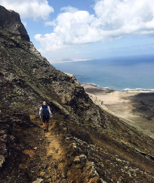
Way of the Gracioseros
The Camino de los Gracioseros trail leading down the cliff was used by the inhabitants of the island of La Graciosa for many years, after arriving in Lanzarote, to get from the coast to the interior of the island (at the Girasol restaurant in Caleta de Sebo you can see pictures of women with baskets of fish wandering up the cliff). This is the only way today, to get to Playa del Risco and Salinas del Rio. The hike is steep and quite challenging – within an hour it comes down with 600 m n.p.m. to sea level, however, the beautiful views of the Chinijo archipelago reward the effort, what you need to put in overcoming the zigzag trail. The route starts behind a small parking lot on the very edge of the cliff – to get there, take the ZY towards Guinate on the LZ-201, and after a kilometer turn onto LZ-202 running north, then take the 1st left onto Calle de las Rositas, next to the aforementioned parking lot. From here you have to go to the end of the asphalt, where the zig-zag trail begins.
Ye-Crown Volcano-Ye
A five-kilometer route from the village of Ye to the summit of the meter 609 m n.p.m. Corona volcano and back is not difficult and over 2 at. almost anyone can beat it. You can leave your car at the church in Ye – several meters behind him, a gently ascending trail begins on the right, which runs between black stone walls practically to the very top of the volcano.
On the way, you can admire the incredible panorama of the north and the center of the island.
There, who will reach the top, will have a unique opportunity, to peer into the volcano's red abyss. It's worth making a trip and walking around the volcano (1 at) – on the south side you can see alcogida, i.e. a special concrete funnel with a tank, which used to be used by residents to collect rainwater flowing down the slopes.
White Spot-White Caldera-White Spot
Trail, which leads between the lava fields to the top of Lanzarote's largest volcano, it is relatively easy. The car must be parked in a small parking lot at the beginning of the route – to get there, from Mancha Blanca you have to take the LZ-67 road to the south. You can see the crossroads just outside the town – instead of turning left after the main road, you should drive straight ahead along an unpaved road towards the volcano visible on the horizon. After a few hundred meters you reach the car park. The trail begins there, which runs through the Parque Natural de los Volcanes, around the smaller volcano La Caldereta towards Cadera Blanca.
At the foot of a mighty volcano, the trail forks, however, both paths lead to the top of the Caldera Blanca, from where you can enjoy amazing views of the island and the Timanfaya National Park. It takes approx. 3 at.